Posts

Heavy Rains Hit Central PA

It’s been raining steadily in much of south-central Pennsylvania for more than 24 hours and rainfall totals in some areas have topped a half a foot. The heavy rains have caused road closures and some schools are closing early and canceling Friday night football games.

The rain was part of a slow moving system approaching the region from the southeast, bringing with it moisture from the Atlantic. Forecasters had predicted another 1-to-2 inches of rain today, with up to 6 inches already reported by the National Weather Service. PEMA reported sporadic flooding in and around the Harrisburg area this morning. The impacted area stretches from the state line all the way north to near Williamsport.

For central PA, the storm system represents the most significant single rainfall since the remnants of Tropical Storm Lee passed through in 2011, dumping up to 15 inches of rain. Some areas were still dealing with damages from that tropical disaster when more flooding hit Thursday night.


Winter Storm Expected to Bring Measurable Snow to Pennsylvania

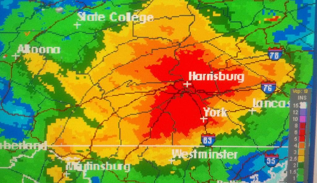
A winter storm warning covers the eastern two-thirds of Pennsylvania. The early season coastal snow storm could bring 4 to 8 inches or even more to some areas before ending Saturday night.

Meteorologist Bill Gartner of the National Weather Service in State College says the risk of power outages is increased because the leaves are still on many trees, and the added weight of the snow could cause limbs to break off and fall on power lines. Thousands of power outages were reported by utilities in the affected areas.

After the storm, temperatures will moderate, so it shouldn’t stick around long. But it could be one for the record books. Looking back at early season snows, State College recorded 4.7″   on October 15th, 2009.  You have to go back to 1925 to find the early season snowfall records for south central Pennsylvania.  A storm on October 30th, 1925 brought 5.4” of snow to Chambersburg, 2” to York, and 2.1” to Harrisburg.

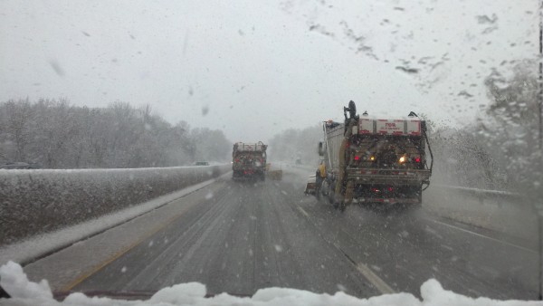
PennDOT had already made its winter preparations before the snow was in the forecast.   Spokesman Steve Chizmar says they’ve already plowed once this season, about a week ago in Centre County.  He says they actually start preparing for the next winter as they wrap up the previous one. Last winter, they used about one million tons of salt and they already have over 600 tons stockpiled and more will be delivered through the season.

There will be a new snow removal method in parts of the state.  Chizmar says they’ve tested tow plows in the last two years and they’ll be deploying about 10 of them this year. He says it’s like a giant plow that’s pulled behind a vehicle. He says when the plow is engaged; it swings out and plows snow in the lane next to the truck.  He says they’re basically accomplishing the work of two plows with one.

Chizmar hopes drivers are ready for winter weather.   He says when roads are slippery, people need to slow down, allow more distance between other vehicles and pay attention to the road. Motorists should check their tires for proper inflation and tread, make sure heaters and defrosters and windshield wipers are working properly and all belts, hoses,  the battery and brakes are in good working order.

Chizmar says don’t forget to clear snow and ice from the vehicle before you drive.  It’s not only a safety measure; it’s the law in Pennsylvania. If ice or snow falls from your vehicle and  injures someone, you can be fined.

Motorists can check 511PA for road conditions before they go out on the highways.


In a Year With Multiple Weather Disasters, Weather Service Wants to Improve Nation’s Readiness

As Hurricane Irene heads toward a possible U. S.  land fall, it’s a reminder of why the National Weather Service has launched a new effort to build a “weather-ready” nation.

The country has already seen nine separate weather-related disasters this year with an economic loss of one billion dollars or more, from floods to tornadoes.

Chris Strager, director of the National Weather Service Eastern Region, says building a more weather-ready nation is going to involve a partnership with other government agencies, researchers and the private sector. He says the country has become more vulnerable to weather extremes with population growth and density in high risk areas, and action needs to be taken to improve readiness.

Strager says they want to look at how their messages are received, how they’re acted upon and what they can ask people to do to be safe from these events.  He says when they conduct post storm surveys; they’ll ask why people did not go to shelter. He says they’re told people heard the warnings, but they’ve heard them before and nothing happened to them those times. Strager says the weather service needs to know how to fix that, to get people to understand what the threat is and to take preparations.

He says people should be preparing for hurricanes and other disasters by having a plan before the storms hit.  He says families need to know where they can go if their home will not provide sufficient shelter. He says families need a checklist to prepare for disasters.

Strager says they’re developing a roadmap to the future for the weather service.  He says these are concepts that are going to take a good deal of planning to get out of the gate, so they’re planning test projects.

To learn more about the project or to get the latest on Hurricane Irene, go to weather.gov

It’s So Hot, You Could Almost…

It’s so hot, you could almost fry an egg on the sidewalk.  From magenta to tangerine, National Weather Service maps are lit up with colors straight out of a box of Crayola crayons.  While it’s a pleasant sight for those of us sitting in the air conditioning, these brilliant hues stand for the Excessive Heat Warnings and Heat Advisories that are issued for most of Pennsylvania.  Temperatures range from the mid-90s to near 100-degrees.  Heat indexes are climbing even higher. 

Curious (well-hydrated and wearing light colored clothing), Radio PA’s Brad Christman and Matt Paul headed outside in an attempt to “literally” fry an egg on the sidewalk.  Around 3:30pm on Thursday, with the air temperature in Harrisburg near 99-degrees… the project was unsuccessful (note the picture above).   

On a serious note, an Excessive Heat Warning means that a prolonged period of dangerously hot temperatures will occur.  According to the National Weather Service, the combination of hot temperatures and high humidity combine to create a dangerous situation.

These conditions make everybody vulnerable to heat-related illnesses, like heat stroke.  “When this happens, body temperatures can rise to excessive levels, 107, 108, 109-degrees.  When that happens it essentially causes a breakdown of critical functions of the body,” says Dr. John Skiendzielewski, director of emergency medicine at Geisinger Medical Center

Dr. Skiendzielewski cautions that senior citizens are especially susceptible. “Because of problems with their circulation… and prior strokes, they just can’t handle that as well as younger individuals can.”  He urges everyone to check on elderly loved ones or neighbors in these conditions.  “The elderly, unfortunately during these economic times, also try to conserve money.  So, they won’t turn on their air conditioners even if they have it,” Dr. Skiendzielewski cautions.  If seniors are having problems, take them some place cooler.

Harrisburg Sets Spring Rain Record

The soggy spring was one for the record books in the state capital.   It is officially the wettest spring ever for Harrisburg.

Matt Steinbugl, meteorologist with the National Weather Service in State College, says they measured 20.79 inches of rain in March, April and May. Steinbugl says that’s more than 9 inches above average, and beats the previous record by more than two inches.

The old record was 18.18 inches set in 1983.

Steinbugl says the area was in a consistent active weather pattern through most of the spring. Annual rainfall in Harrisburg averages about 41.45 inches, so the city has already seen half of its annual average in the first three months of the year. Meteorological summer began on June 1st.

More Tornadoes Confirmed from Storms in the Past Week in Pennsylvania

As devastating tornadoes have hit parts of the country this spring, Pennsylvania has not been immune to the vicious storms.   Pennsylvania averages 15 to 20 tornadoes a year.  June and July are usually the peak months.  With the latest confirmations, the state has already reached the average.

The National Weather Service in State College sent teams out on Friday to review damage from the night before.  They confirmed at least four more tornadoes. All were given a preliminary rating of  EF1. The confirmations came from near Hogestown in Cumberland County,   in New Franklin in Franklin County, near  Dauphin Borough in Dauphin County, and in Schuylkill County near Schuykill Haven . Then on Friday, a waterspout was reported on Raystown Lake and another EF1 tornado was confirmed near Calvin in Huntingdon County.

Peter Young is a warning coordination meteorologist with the National Weather Service in State College.  He says some people might think that the mountains protect parts of Pennsylvania from tornadoes, but that really has not been the case.  He says tornadoes have been confirmed across the state. He says in the 1985 outbreak, the state had large tornadoes go up one side of a mountain and come down the other side.

Tornadoes in Pennsylvania tend to be smaller in size and usually do not stay on the ground as long as storms that hit Tornado Alley.  But Pennsylvania has seen one EF5 in its history, during that deadly 1985 outbreak in Northwestern Pennsylvania which also included an EF4 that stayed on the ground for an hour.

Young says people should heed tornado warnings when they are issued, and take shelter.  He adds severe thunderstorms can spin off small tornadoes and those warnings should not be ignored.