Posts

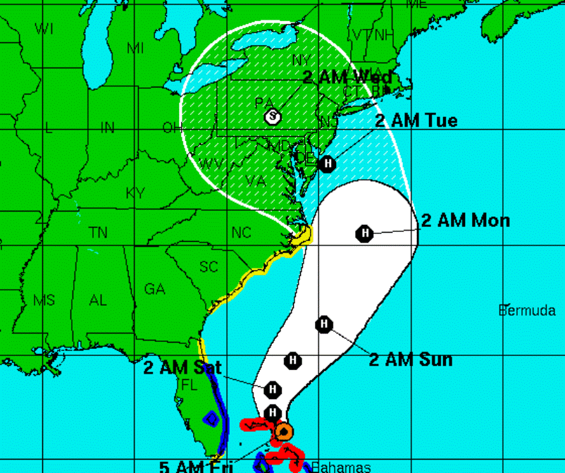
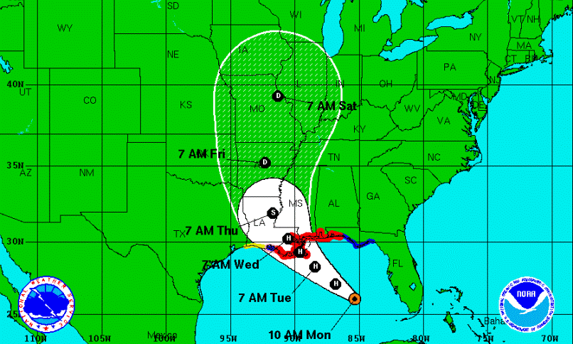
Heavy Rains Hit Central PA

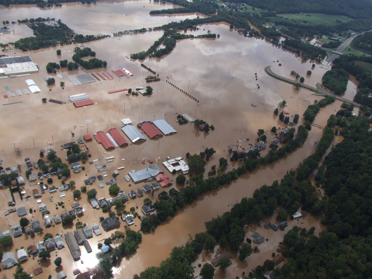
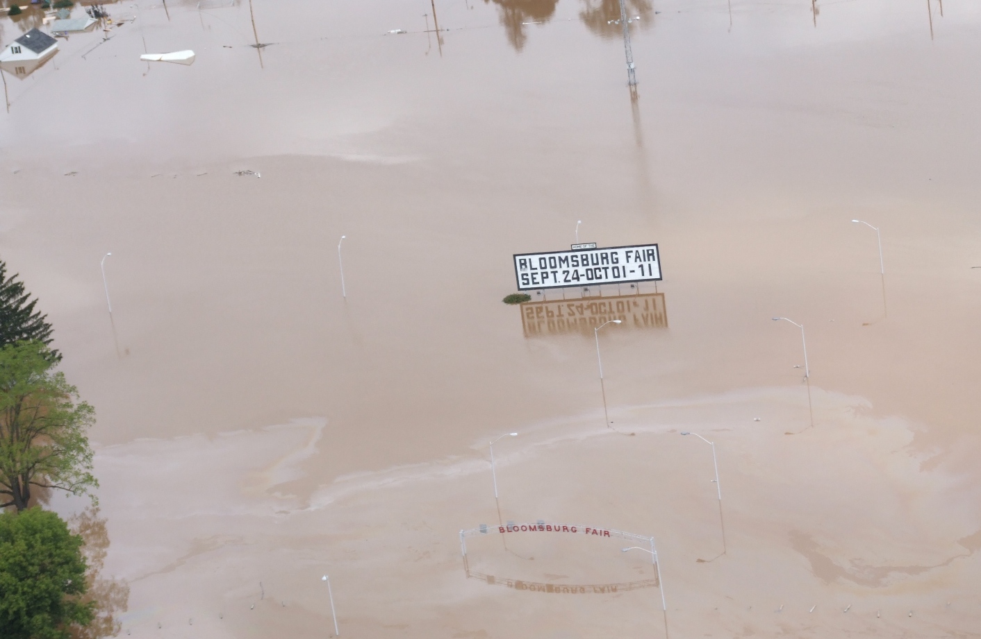
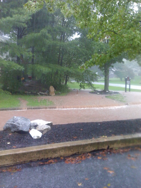
It’s been raining steadily in much of south-central Pennsylvania for more than 24 hours and rainfall totals in some areas have topped a half a foot. The heavy rains have caused road closures and some schools are closing early and canceling Friday night football games.

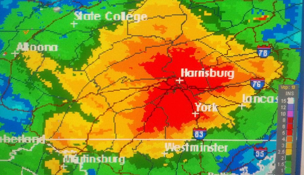
The rain was part of a slow moving system approaching the region from the southeast, bringing with it moisture from the Atlantic. Forecasters had predicted another 1-to-2 inches of rain today, with up to 6 inches already reported by the National Weather Service. PEMA reported sporadic flooding in and around the Harrisburg area this morning. The impacted area stretches from the state line all the way north to near Williamsport.

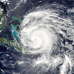
For central PA, the storm system represents the most significant single rainfall since the remnants of Tropical Storm Lee passed through in 2011, dumping up to 15 inches of rain. Some areas were still dealing with damages from that tropical disaster when more flooding hit Thursday night.


Latest Forecast Tracks Bring Sandy to Pennsylvania on Tuesday & Wednesday

The effects of Hurricane Sandy may reach Pennsylvania as early as Sunday, but according to the National Hurricane Center the storm itself is expected to come ashore near the New Jersey-Delaware border and then track directly over Pennsylvania late Tuesday and into Wednesday.

The main concern is that the tropical storm could collide with a westward-moving early winter system and park itself over the region for days, bringing heavy rains, winds and possibly snow in higher elevations. Officials are urging everyone in the path of Sandy to use their time wisely this weekend, preparing emergency kits with at least three days of drinking water and other necessities, as well as clearing storm drains and spouting, which may be clogged with fallen leaves.

A spokesperson for the Pennsylvania Emergency Management Agency says this potential “superstorm” could bring prolonged power outages that may last several days.

PA Remains Out of Isaac’s Projected Path

Tropical Storm Issac is expected to become a Hurricane by tonight, and as it passes by the Republican National Convention in Tampa, Isaac’s projected track shows the storm making landfall on the Gulf Coast and affecting the Midwest. As of Monday morning, Pennsylvania remained well outside the expected cone of probability, but the storm could provide some much needed drought relief in the southern and Midwestern regions of the U.S.

A year ago, another “I” storm, Irene, was wreaking havoc in Pennsylvania. That storm brought high winds and flooding to the Commonwealth as it ambled up the East Coast, knocking out power and prompting coastal evacuations.

Two more tropical disturbances in the Atlantic are currently being monitored by the National Hurricane Center.


Flood Recovery Efforts Begin

The unofficial death toll stands at 12, according to Governor Tom Corbett’s latest briefing.  “I believe though that a combination of planning, quick response by emergency responders throughout the affected region and the bravery of those emergency crews have prevented that number from going higher,” Corbett says.  State officials estimate that more than 2,000 homes have been damaged.  

The governor says the recovery phase of the flooding disaster will be long and difficult.  “It’s going to be the coordination of the local, county, state and federal [governments].  Many people are going to be asking for help.” 

Flooding -- Bloomsburg.

The Bloomsburg Fairgrounds were overtaken by the Susquehanna River. Volunteers are now helping in a massive cleanup operation to get ready for opening day.

Some northeastern Pennsylvania residents haven’t even been able to get back into their homes to view the damage.  “At the height there were 21-shelters open, there are still 16-shelters open,” explains Red Cross public affairs manager Janice Osborne.  “Our primary role right now is to provide shelter for people, to provide food, and for the immediate emergency needs such as emotional counseling, toiletry items.” 

The Red Cross is preparing and distributing 20,000 hot meals a day.  Cleanup supplies are arriving by the truckload, but they still need your monetary helpBlood donations are also valuable, as Osborne says many of the blood donation collection sites had to close down due to the flooding.

The Department of Environmental Protection (DEP) is warning affected residents not to rush back into their homes, as they must be dried and thoroughly cleaned first.  Everything the flood water touched should be disinfected, but many items – like mattresses and carpets – are better off in the dumpster.

Remnants of Lee Cause Flooding in Pennsylvania, Rivers Could Hit Major Flood Levels

It has been a day of flash flooding, periods of drenching rain and water rescues for parts of the state, with some of the worst problems on either side of the Susquehanna.   The remnants of Tropical Storm Lee have been pushing streams and creeks over their banks and overloading drainage systems.  By mid-morning, some areas near Harrisburg had gotten almost 6 inches of rain, with 7 reported in Bethlehem and near Dover in York County.

Peter Young, warning coordination Meteorologist at the National Weather Service in State College, says because the rain is associated with a tropical system, it has been coming in bands.  This means some areas are getting hit harder than others. Flood watches and warnings were issued for much of Central and Eastern Pennsylvania.

There is a risk of major flooding along the Susquehanna River if the forecast holds.  Ben Pratt, a Hydraulic engineer with the Susquehanna River Basin Commission, says the river should crest at Harrisburg by Friday evening.

Major flooding is also possible in Marietta to the south and Wilkes Barre to the north. Pratt says people who have interests or live along the river need to pay close attention to the forecast.

The Pennsylvania Emergency Management Agency has raised its readiness to level 2 at the Emergency Operation Center.  Officials have  brought in emergency preparedness liaison officers from key agencies such as the National Guard, State Police and PennDOT as they plan for the possibility of major flooding on the Susquehanna, Delaware and Juniata Rivers.

The Clean-up and Recovery Begins…

As crews tried to restore power to hundreds of thousands of customers left in the dark by Hurricane Irene, state officials continued their efforts to set Pennsylvania on the path to recovery in the wake of the enormous storm.

Governor Tom Corbett provided updates on the state’s fatalities Sunday, including people killed by falling trees in Dauphin, Monroe and Luzerne counties. A fourth person died after losing control of their car along the Pennsylvania Turnpike in Carbon County. Authorities in Montgomery County say the body of a woman was discovered in a creek near her abandoned car. The death toll stood at five by Monday morning, but more reports of storm-related fatalities were possible.

Flood waters threaten vehicles in suburban Philadelphia Saturday night

Officials also say the flooding threat is not over. The Delaware River will crest above flood stage Monday and other waterways throughout eastern Pennsylvania will be affected as the rains dumped by Irene to the north of us run off to the south.

Governor Corbett has asked Washington for federal disaster assistance for at least 11 counties affected by Hurricane Irene: Bucks, Chester, Delaware, Lehigh, Monroe, Montgomery, Northampton, Philadelphia, Pike, Wyoming and Wayne.

While Irene is gone, another potentially dangerous storm system is developing in the eastern Atlantic. Tropical Depression 12 is expected to be a hurricane by Thursday as it moves slowly westward.