


On this week’s Radio PA Roundtable, Brad Christman and Matt Paul sum up the impact of “Superstorm” Sandy and bring you details on the indictment of former Penn State University President Graham Spanier. Matt will also bring you an interview with incumbent state Treasurer Rob McCord after last week profiling his Republican challenger.
Radio PA Roundtable is a 30-minute program featuring in-depth reporting on the top news stories of the week.
Click the audio player below to hear the full broadcast:
[audio:https://s3.amazonaws.com/witfaudio/radiopa/Roundtable11-02-12.mp3]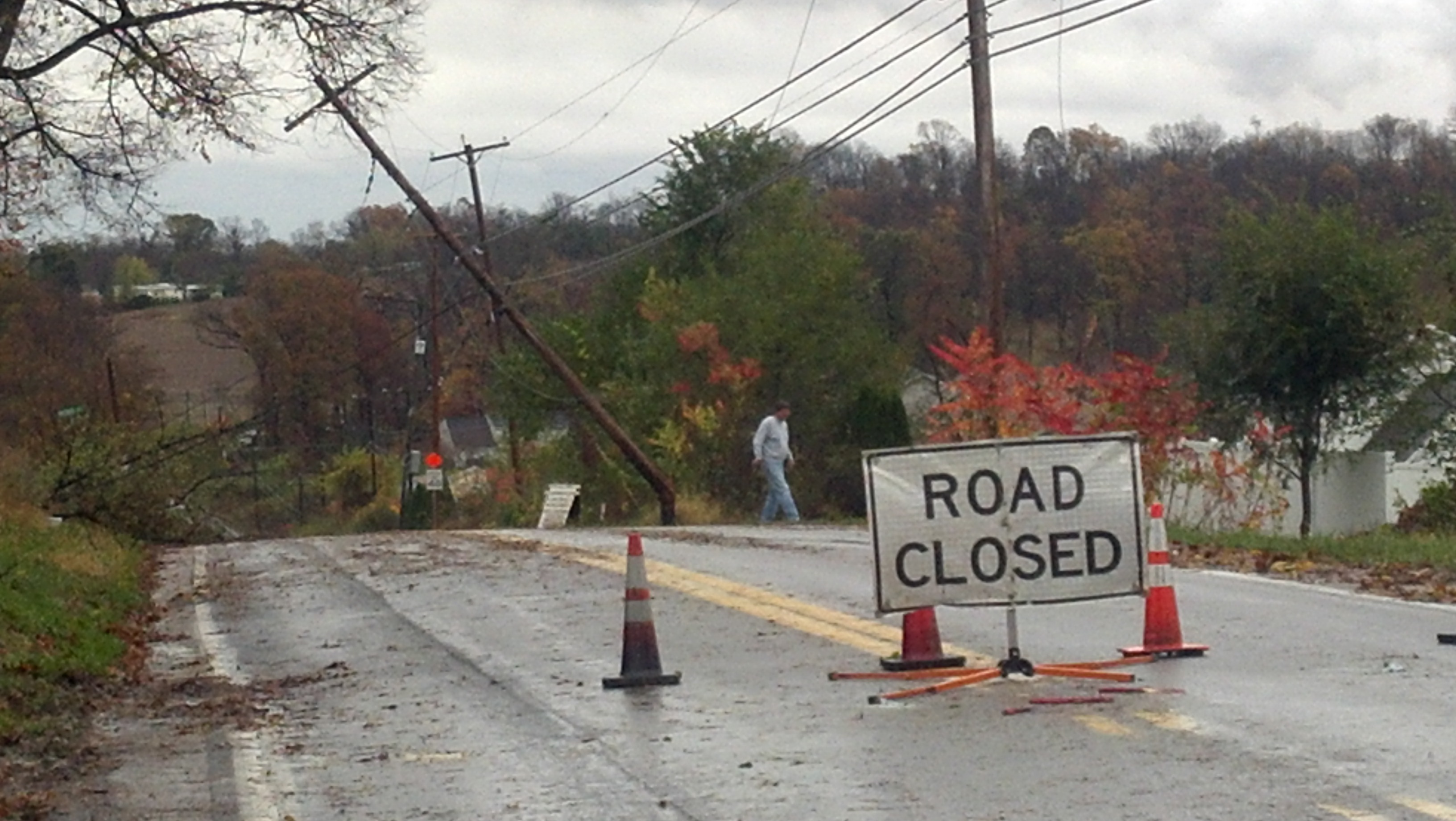
As of Tuesday morning, more than 400 roads and bridges were still closed across the state in the wake of Hurricane Sandy. PennDOT is still assessing the amount of damage.
Crews started damage assessments where it safe to do so, but some bridge inspections will have to wait until the water recedes PennDOT spokeswoman Erin Waters says some roads were closed due to wires and trees down but others were affected by flooding. Most of the closures were in the southeastern quadrant of the state, the Lehigh Valley and parts of the Capital Region.
Waters reminds drivers that a new Pennsylvania law sets fines for those who do not obey road closure signs and barricades. The fine goes up if the person has to be rescued. She adds people should not drive around just to see the damage or take photos of it; that could impede utility and road crews from doing the work needed to reopen roads and restore power.
For the latest on road conditions, go to 511PA.com

State emergency management officials cited significantly diminished winds as, as the storm that used to be Hurricane Sandy slowly moved through western Pennsylvania and into New York.
There are reports of minor flooding across the state’s southern counties and 1.25-million Pennsylvania households were without power as of the midday briefing. 900-people have also sought aid in 57-shelters that have been established across the state.
But the problems are much worse in neighboring New York and New Jersey. “There are two mega-shelters being established to house people coming in from out-of-state,” Governor Tom Corbett explained. One, at West Chester University, will house up to 1,300 displaced New Jersey residents. Another, at East Stroudsburg University, will house up to 500 displaced New Yorkers.
Pennsylvania is also sending those states 35- ambulances and a variety of incident management teams, according to PEMA director Glenn Cannon.
A state of major disaster has already been declared in New York and New Jersey. Pennsylvania’s would-be major disaster declaration will have to wait until the damages are tallied, but Governor Corbett says the state will at least receive federal assistance for its storm prep. “Frankly I believe our preparation for the storm, in many respects, kept much of the damage in check, particularly when it comes to life and injuries.”
At least three Pennsylvania deaths have been confirmed in connection with the storm. Two of them involve falling trees, the third was the result of a traffic accident. That number may rise in the hours ahead.

Gov. Corbett has been working out of the PEMA headquarters since Sunday.
Corbett will be at Ft. Indiantown Gap, this afternoon, to visit with some of the 2,000 National Guard troops that have been activated for the disaster response. Then it’s back to the PEMA emergency operations center for an evening briefing on the storm, and Corbett plans to tour some of the hardest-hit areas of the state on Wednesday and Thursday.

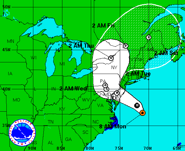
Hurricane Sandy was reclassified as a post-tropical cyclone after making landfall in New Jersey Monday night and by midnight, the system was making its way over Philadelphia and farther into Pennsylvania. By sunrise, the center of the system was spinning in south-central PA, in and around Franklin County.
The storm is expected to turn north and move on into New York state and New England tomorrow. The remnants of Sandy still pack some strong wind gusts, but much of the torrential rain has ended. Light-to-moderate rain will continue for those in the path of the storm. Rainfall totals associated with Sandy were highest along the southern border with Maryland in eastern Pennsylvania where 6-8 inches of rain fell on Monday. A portion of central Pennsylvania southeast of Altoona also checked in with 6-8 inches according to the National Weather Service.
More than a million power customers were without service as the sun came up on Tuesday. PPL reported nearly 400,000 customers in the dark early this morning, while PECO was scrambling to restore power to hundreds of thousands in the five-county Philadelphia region. The First Energy companies (West Penn, Met-Ed, Penelec & Penn Power) also reported widespread outages which were most heavily concentrated in Berks and Northampton counties.

Officials at PennDOT and the Pennsylvania Turnpike are asking people from the state capital region eastward to avoid unnecessary travel if possible.
Speed limits have been lowered to 45 miles an hour on the Turnpike from Carlisle east and on a number of major highways and interstates in the eastern half of the state. Certain trucks, trailers, RVs and motorcycles have been restricted from those roads that have the reduced speed limit.
Officials say the high winds from Sandy are the reason for the restrictions. To get a full list of roads and travel conditions, go to 511PA, PennDOT’s website or the Pennsylvania Turnpike’s website.

Everybody knew the outages would come. Thousands have already been reported, and thousands more are expected to pile up through the evening and overnight hours when the storm is expected to be most severe. “Restoration efforts are going to take time,” stresses Pennsylvania Public Utility Commission (PUC) Chairman Robert Powelson.
“Right now in Pennsylvania there are over 2,000 extra, mutual assistance line workers coming in from other states to help us,” Powelson explains, while adding that it may take some time before the conditions are safe enough for those line workers to make the needed repairs.
Pennsylvanians can track power outrages via special websites that PPL, PECO and First Energy have established.
PPL Electric Utilities got out ahead of the storm by sending its customers this robocall on Sunday night:PPL-ROBOCALL
Better communication and the proper management of expectations are two lessons that Powelson says the electric utilities learned from last year’s storms.
If your power goes out, contact your utility immediately. The PUC says you should not rely on your neighbor to do it. You should NOT call 911 to report a power outages, as officials say those lines must be reserved for emergencies.
Officials say to remain indoors and away from windows for the duration of the storm. Once the storm passes, however, you may see fallen power lines. The PUC says to stay away from those lines and to notify your utility company.
Beginning at 10:00am on Monday, PennDOT and the Pennsylvania Turnpike Commission is temporarily reducing the speed limits on some southeast PA roadways.
The move is in response to the high winds and other dangerous conditions associated with Hurricane Sandy, the monster storm which is nearing landfall in New Jersey. Officials are urging motorists to avoid any unnecessary travel, but those who do have to be on the roads will be subject to a reduced 45 MPH speed limit.
That reduction includes traffic on the following roadways:
Today’s order also includes a restriction on the following types of vehicles on these highways:
Vehicles in these classifications should pull over to a safe area and wait for the restriction to be lifted. These restrictions may be expanded to other parts of the state as Sandy starts its move inland.

As Hurricane Sandy continues on its collision course with Pennsylvania, utilities are preparing for high winds to wreak havoc with the electricity grid.
Officials with Allentown-based PPL say the utility has brought in 1500 extra crew members from as far away as Arkansas to deal with the aftermath of Hurricane Sandy. Utility trucks have been amassing in numerous staging areas near major highways Monday morning as they prepare to be dispatched to trouble spots. The high winds associated with Sandy could uproot trees and knock down numerous power lines. Officials say power outages could last several days.
West Penn, Penelec, Met-Ed and other utilities are also scrambling their work force and preparing for emergency repairs.
Tropical storm-force winds are expected to top 60 MPH as the center of Sandy moves into the Keystone State by early Tuesday. Torrential rainfall is expected to begin today with totals reaching up to 10 inches.
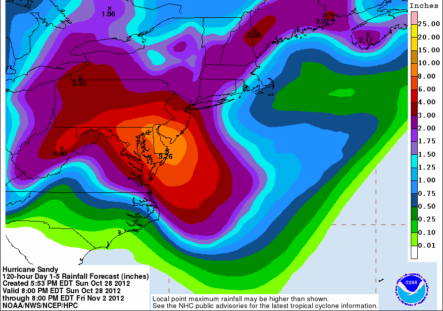
The early effects of Hurricane Sandy began moving into Pennsylvania late Sunday and with the heaviest rainfall expected on the front side of the massive storm, the flash flooding risk begins today.
The National Weather Service is projecting as much as 10 inches of rainfall associated with Sandy, with the heaviest rains coming in the southeast and southern tier portions of the Commonwealth. Rain will be the main threat on Monday, with high winds taking over late in the day and into Tuesday. Officials are reminding residents to clear their porches and yards of items that might become projectiles in Tropical Storm-strength winds. The winds could also knock out power for large areas of the state, much like they did in last year’s Hurricane Irene.
President Obama has declared a disaster emergency for Pennsylvania and other states in the storm’s path. That will allow Governor Tom Corbett to apply for federal assistance for the steps taken to prepare for Sandy.