Hurricane Irene Could Impact Pennsylvania Weather, Depending on Track
Hurricane Irene potential path may bring it close enough that it could impact parts of Pennsylvania this weekend. The latest forecast has it taking a slightly more westward track.
Walter Drag, with the National Weather Service in Mount Holly New Jersey, says it’s a large storm that could have some impact on Pennsylvania, depending on the track it takes up the coast.
Drag says some areas that had heavy rain recently, in Eastern Pennsylvania, New Jersey, Northern Delaware and Northeastern Maryland could be facing another bout of heavy rain as the result of Irene.
Drag says even if the storm passes off to the east, a predecessor rainfall event could still bring some rain to eastern parts of the state. Predecessor events can be associated with tropical systems. They are not part of the bands of rain directly caused by the hurricane or tropical storm.
Drag says if the storm comes closer, it could bring squally winds and heavy rainfall. The Philadelphia area could get anywhere from a fraction of an inch to more than five inches, depending on the track of the storm.
Drag says people who have weekend plans along the coast should pay special attention to the National Hurricane Center forecasts. The head of FEMA says people along the entire Eastern Seaboard need to pay attention to Hurricane Irene.
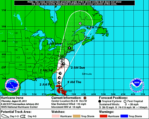
**Chart courtesy of the National Hurricane Center