

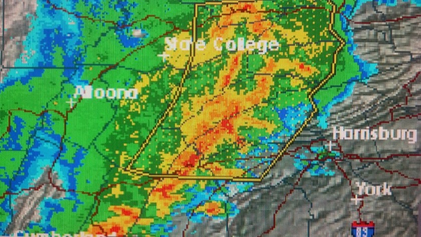
The weather system feared to form a phenomenon known as a derecho began moving into Pennsylvania early this morning, sweeping through western PA in the 3 and 4 o’clock hours and then continuing its path across the Commonwealth. Much of the state is in store for severe thunderstorms, heavy rain and damaging winds, along with the possibility of tornadoes and large hail. The saving grace is that the system is moving rapidly. As the storms moved into PA, it appeared that the middle swath of the state would see the strongest thunderstorms, while the heaviest sustained rains could come in the northern and southern tiers.
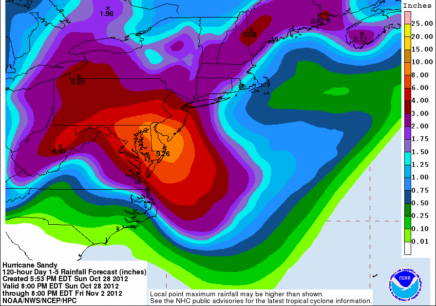
The early effects of Hurricane Sandy began moving into Pennsylvania late Sunday and with the heaviest rainfall expected on the front side of the massive storm, the flash flooding risk begins today.
The National Weather Service is projecting as much as 10 inches of rainfall associated with Sandy, with the heaviest rains coming in the southeast and southern tier portions of the Commonwealth. Rain will be the main threat on Monday, with high winds taking over late in the day and into Tuesday. Officials are reminding residents to clear their porches and yards of items that might become projectiles in Tropical Storm-strength winds. The winds could also knock out power for large areas of the state, much like they did in last year’s Hurricane Irene.
President Obama has declared a disaster emergency for Pennsylvania and other states in the storm’s path. That will allow Governor Tom Corbett to apply for federal assistance for the steps taken to prepare for Sandy.
Sunday marks 21 years to the day after the formation of the system that became known as “The Perfect Storm.” Also known as the Halloween Nor’easter of 1991, the system was a confluence of a hurricane and a cold front. The ensuing monster storm lashed the east coast for days and was immortalized in the movie that highlighted the story of the Andrea Gail, a commercial fishing vessel lost at sea.
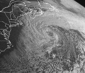
Flash forward to 2012 and similar weather ingredients are cooking in the Atlantic and over land. Forecasters say Hurricane Sandy, currently expected to run parallel to the East Coast, could clash with an early winter system moving in from the west and a blast of arctic air from the north. The result could be several days of winds, heavy rain and possibly snow in parts of the east.
The systems are expected to begin having an impact in the Mid-Atlantic region on Sunday with the worst of the storms coming late Monday or early Tuesday.

Six Pennsylvania cities made the Asthma and Allergy Foundation of America’s list of the 100 worst places to live with spring allergies.
The good news is that you’ll have to look a little further down the list to find the Pennsylvania locales; the bad news is that it’s going to be a difficult spring for allergy sufferers, no matter where they live.
Asthma and Allergy Foundation of America Vice President Mike Tringale says the extremely mild winter has given way to an allergy season that started earlier. “An earlier season means the trees bloom and pollinate earlier, they bloom and pollinate longer, and they bloom and pollinate with greater ferocity.”
Tringale says the best way to be prepared is to get properly diagnosed, talk to your doctor about over-the-count medications and consider nasal rinsing to clear out those sinuses.
The spring allergy rankings were based on cities’ pollen scores, per capita use of allergy medicines and density of board certified allergists. Philadelphia is the first Pennsylvania city to appear on the 2012 list, in the 30th position. It’s followed by Pittsburgh (33), Allentown (41), Scranton (44), Harrisburg (61) and Lancaster (75).

The miserably hot weather that’s been gripping the Midwest is beginning to take hold of Pennsylvania. With every heat wave, Dr. Richard O’Brien treats multiple cases of heat related illness. He says nobody is immune to the temperatures. “Often they are sporting people, and sometimes they are little old ladies going to church,” says O’Brien, spokesman for the Pennsylvania Chapter of the American College of Emergency Physicians and associate professor of emergency medicine at The Commonwealth Medical College.
The three basic levels of heat illness include: heat cramps, heat exhaustion and heat stroke. “Heat exhaustion is a little more serious, we often use IV fluids for that; you might need a visit to the hospital for that. Heat stroke is very serious and life threatening. Think of heat stroke as being as serious as a real stroke,” O’Brien cautions.
The symptoms of heat exhaustion can include weakness, dizziness and shortness of breath. “You need to seek care. You need to lie down, you need to be cooled off, you need to be hydrated,” O’Brien tells us. He says the key is to keep heat exhaustion from becoming heat stroke.
Dr. O’Brien urges everyone to limit activities and to keep well-hydrated in this weather: “The reason why we hydrate is so that we can sweat, so that we don’t overheat, so that we don’t get sick.” He points out that children and the elderly are especially vulnerable to heat illness.
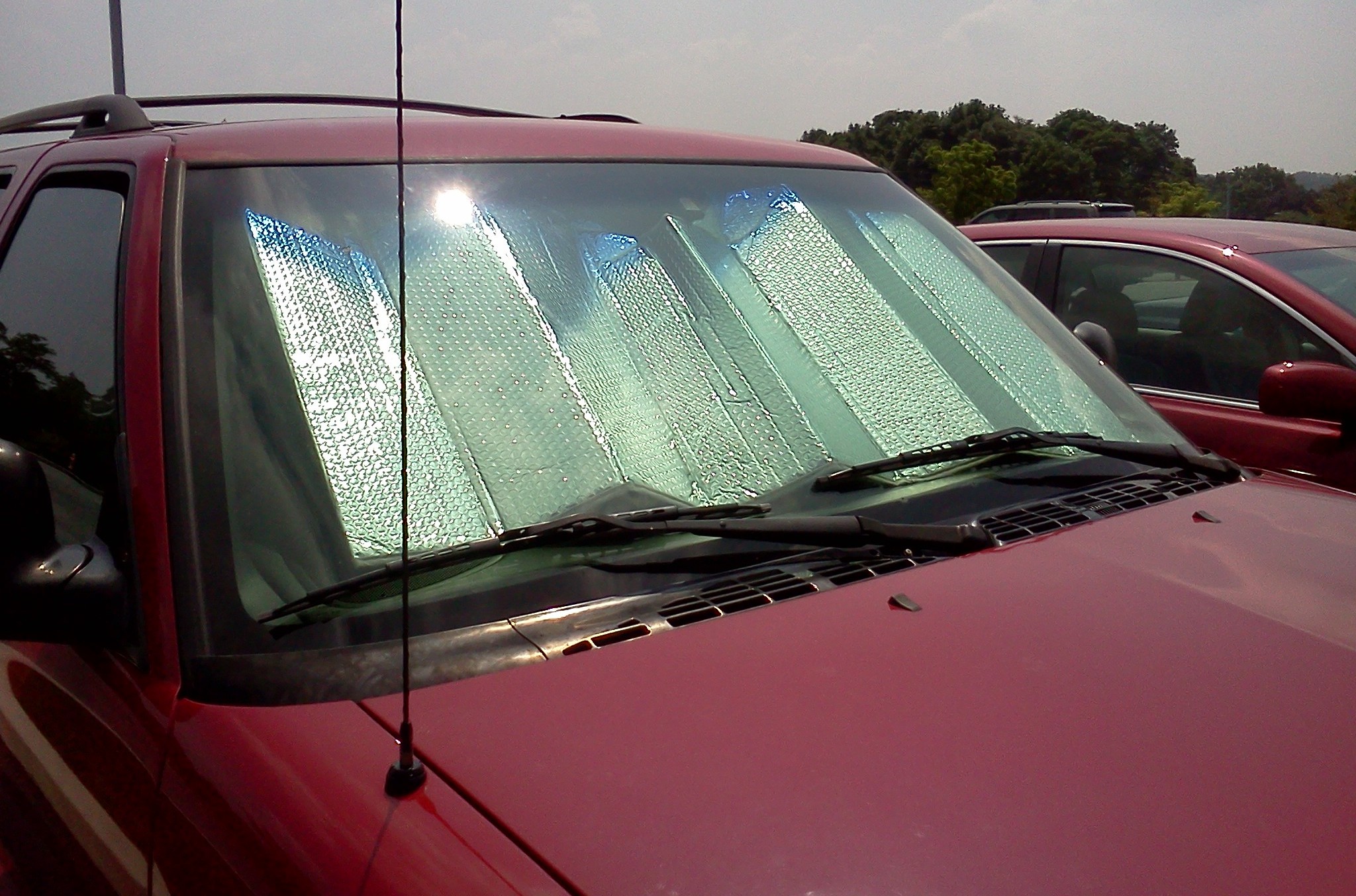
AAA Says a Sun Shield Can Minimize Heat Buildup and Protect Your Car's Interior
With children’s safety in mind, AAA is urging us never to leave kids alone in car. Once a car is locked up, temperatures inside can climb by 20-degrees in the first 10-minutes. “The inside of a car, on a day like this – with temperatures in the 90s – can reach 200 degrees,” says AAA Mid-Atlantic spokesperson Jim Lardear. “You can cook food… at that temperature,” Lardear warns.
The National Highway Traffic Safety Administration reports at least 27-documented child deaths, per year, which are linked to hot vehicles. Both O’Brien and Lardear say these safety rules for hydration and car safety apply to our pets too.